Roof Conditions Visible From Every Angle
Aerial Photography by Drone in Point Pleasant for rooflines that cannot be safely reached by ladder or on foot
Max Value Home Inspections uses drone-assisted roof and exterior evaluations to give you a full picture of your property without the risk or delay of manual access. When your roofline spans multiple levels, includes steep pitches, or sits behind tall vegetation, traditional inspection methods leave gaps. This service captures high-resolution imagery of elevated and hard-to-access areas, providing documentation that supports accurate reporting and informed decision-making during the sale, purchase, or maintenance of a property.
The drone survey documents shingle condition, flashing integrity, chimney caps, gutter alignment, and soffit ventilation across the entire roofline. You see what the inspector sees, and the images become part of your permanent record. Properties with detached structures, extensive grounds, or complex architectural layouts benefit from this coverage, especially when timing or safety concerns limit physical roof access.
If your property includes features that require elevated review or you want a complete visual record of your exterior condition, reach out to schedule a drone survey in Point Pleasant with advance notice based on scope and local conditions.
How Drone Imaging Supports Better Property Assessments
The aerial survey begins with a pre-flight assessment of the site, weather conditions, and any temporary obstructions such as construction equipment or nearby utility work. The drone follows a programmed flight path that captures overlapping images from multiple angles, ensuring full coverage of the roof surface, parapet walls, and exterior features that are otherwise difficult to observe.
After the flight, you receive annotated imagery that highlights areas of concern such as missing shingles, pooling water, moss accumulation, or flashing separation. Max Value Home Inspections incorporates this documentation into your inspection report, and the high-resolution files remain available for reference during repair consultations or contractor bids. You walk away with a visual baseline that reflects the true condition of your roof and exterior envelope at the time of service.
Advanced scheduling may be required depending on property size, weather windows, and airspace conditions. The service is particularly useful when combining roof evaluation with a full home inspection, as the imagery supports findings from ground-level observations and thermal scans. Drone surveys do not replace manual inspection but extend the reach of the evaluation to areas where physical access is impractical or unsafe.
Common Questions About Drone-Assisted Inspections
Clients often ask how drone imaging fits into the broader inspection process and what it can and cannot reveal about roof condition in coastal and suburban settings.
What does the drone capture that a ladder inspection cannot?
The drone documents the entire roof surface in one session, including ridgelines, valleys, and rear elevations that are blocked by trees or adjacent structures, without requiring multiple repositions or safety equipment.
How soon after scheduling can the drone survey be completed?
Most flights are scheduled within a few days of the inspection appointment, but weather conditions and airspace restrictions in Point Pleasant may require adjustment to ensure safe and legal operation.
Why is high-resolution imagery important for a home inspection report?
The images provide a timestamped visual record that supports written findings, clarifies the extent of damage, and gives contractors precise reference points for repair estimates or warranty claims.
When is drone imaging required versus optional?
It becomes necessary when the roof cannot be accessed safely due to height, pitch, or structural instability, and it is optional when the inspector can reach all areas by ladder but the buyer or seller wants enhanced documentation.
What happens if weather delays the scheduled drone flight?
Max Value Home Inspections will reschedule the aerial portion of the inspection for the next available weather window, and the ground-level evaluation proceeds as planned to avoid disrupting your transaction timeline.
If your property includes complex rooflines, coastal exposure, or features that require elevated review, contact Max Value Home Inspections to confirm drone availability and scheduling requirements for your upcoming inspection in Point Pleasant.
Standard Home Inspection
STANDARD HOME INSPECTION:
At MAX VALUE Home Inspections, we perform every New Jersey residential home inspection with exceptional thoroughness, precision, and care. From the foundation to the roof and every system in between, we methodically evaluate the property as if it were our own, taking the time to examine each major component and clearly communicate what we observe. Our commitment extends beyond the structure - we prioritize the needs of both buyers and sellers, taking the time to clearly explain our findings, answer questions, and provide practical guidance that empowers confident decisions. We understand that a home transaction is one of life's most important investments, and we approach each inspection with professionalism, respect, and genuine concern for everyone involved, helping to protect both the client's future and the integrity of the transaction.
YOUR REPORT:
Immediately upon completion of our evaluation of your home, we will present you with a brief oral report of our findings, going over all important issues with you on the spot. You'll have a general idea of the condition of your home and we'll gladly take the time to answer any questions you have.
Your finalized report will be available 24-48 hours following our inspection. We will compile our findings using Spectora software, which generates straightforward notes alongside clear photos in a concise, organized format. Combined with professional guidance from your inspector, you'll receive all the information you need to make the best decision with confidence.
MAX VALUE Home Inspections - Your smart move starts here!
Our Standard Home Inspection starts at $399* based on square footage, which includes:
-Exterior Walls, Walkways, Driveway, Doors, and Windows
-Roof, Eaves, Soffits, and Drainage Systems
-Interior Walls, Floors, Ceiling, Doors, and Windows
-Attached Garage
-Electrical Systems
-Plumbing Systems
-Heating System
-Cooling System
-Fireplace and Chimney
-Attic and Insulation
-Foundation, Basement, and/or Crawlspace (not including WDO report)
*See pricing for additional details
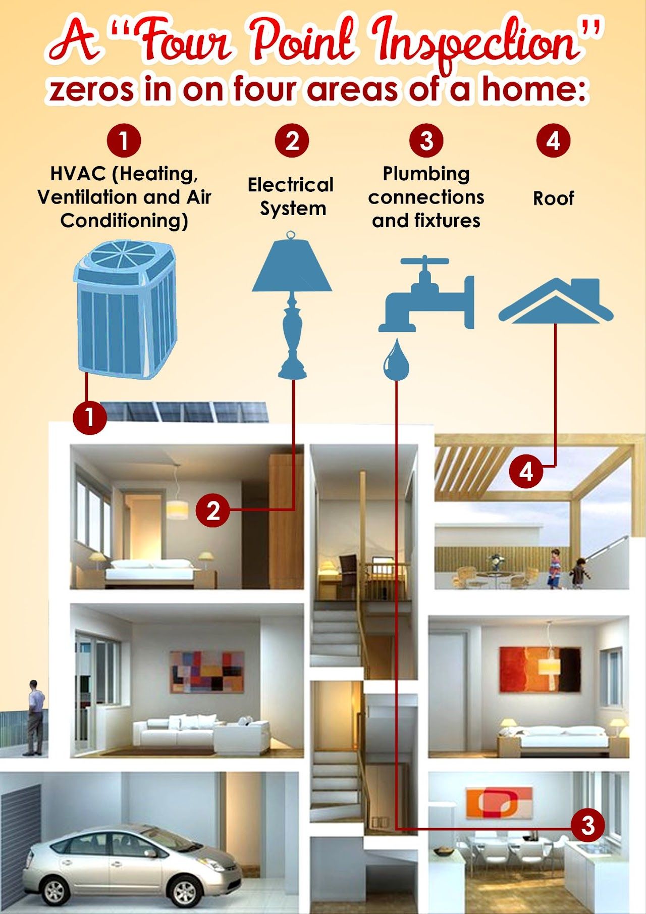
Four Point Inspection
FOUR POINT INSPECTION:
Depending on the age of the home you own, an insurance company may require a condensed inspection to issue or renew a policy. A Four-Point Inspection gives you fast, focused insight into a home’s most critical systems—and that’s exactly what MAX VALUE Home Inspections delivers. We thoroughly evaluate the roof, electrical, plumbing, and HVAC systems to identify safety concerns, age, and overall condition, helping homeowners, buyers, sellers, and insurers make confident decisions. Our clear, easy-to-understand reports highlight issues that may affect insurability or future repair costs, without unnecessary fluff or alarm. Whether you need an inspection for insurance purposes or peace of mind, MAX VALUE Home Inspections provides accurate, professional, and reliable four-point inspections you can trust.
YOUR REPORT:
Immediately upon completion of our evaluation of your home, we will present you with a brief oral report of our findings, going over all important issues with you on the spot. You'll have a general idea of the condition of your home and we'll gladly take the time to answer any questions you have.
Your finalized report will be available 24-48 hours following our inspection. We will compile our findings using Spectora software, which generates straightforward notes alongside clear photos in a concise, organized format. Combined with professional guidance from your inspector, you'll receive all the information you need to make the best decision with confidence.
MAX VALUE Home Inspections - Your smart move starts here!
Our Four Point Home Inspection starts at $299, plus $50 for each additonal HVAC Zone
-Roof
-Electrical systems
-Plumbing systems
-Heating and Cooling (HVAC) systems
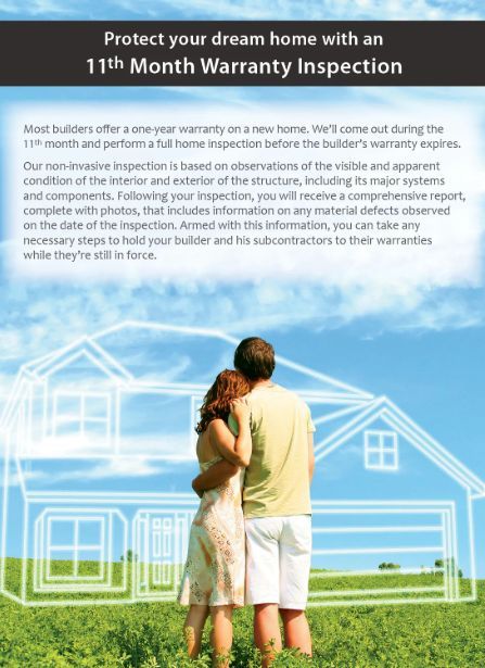
11th Month Inspection
11th MONTH INSPECTION:
An 11th Month Inspection is your last chance to catch issues before your builder’s warranty expires—and MAX VALUE Home Inspections makes sure nothing is missed. Homes often develop hidden defects during the first year, including settlement cracks, drainage issues, roof deficiencies, and HVAC performance problems. This inspection is performed with meticulous, room-by-room, system-by-system, item-by-item detail to identify even minor defects before the builder's warranty expires. Our detailed inspection identifies construction defects, safety concerns, and even cosmetic issues while corrections are still the builder’s responsibility, potentially saving you thousands in future costs. Protect your investment, preserve your warranty rights, and gain peace of mind with a professional 11th Month Inspection from MAX VALUE Home Inspections.
YOUR REPORT:
Immediately upon completion of our evaluation of your home, we will present you with a brief oral report of our findings, going over all important issues with you on the spot. You'll have a general idea of the condition of your home and we'll gladly take the time to answer any questions you have.
Your finalized report will be available 24-48 hours following our inspection. We will compile our findings using Spectora software, which generates straightforward notes alongside clear photos in a concise, organized format. Combined with professional guidance from your inspector, you'll receive all the information you need to make the best decision with confidence.
MAX VALUE Home Inspections - Your smart move starts here!
Our 11th Month Home Inspection starts at $399* based on square footage, which includes:
-Exterior Walls, Walkways, Driveway, Doors, and Windows
-Roof, Eaves, Soffits, and Gutters
-Interior Walls, Floors, Ceiling, Doors, and Windows
-Attached Garage
-Electrical systems
-Plumbing systems
-Heating system
-Cooling system
-Fireplace and Chimney
-Attic and Insulation
-Foundation, Basement, and/or Crawlspace (not including WDO report)
*See pricing for additional details
Additional Services
As add-on services* to your Standard Home Inspection, you may also choose:
-Wood Destroying Organisms: $79 (Not NJ State Termite report)
-Detached Garage Inspection: $99
-Pool or Spa Inspection: $299
-Deck Inspection: $79
-Appliance Recall report: $49
-Radon Testing: Call for pricing, advanced scheduling may be required
-Underground Tank Sweep: Call for pricing, advanced scheduling may be required
-Drone Surveys: Call for pricing, advanced scheduling may be required
*Add-on service pricing is based on performing the service at time of standard inspection. Call for pricing if you would like any add-on service(s) performed without a standard inspection. Discounted rates on 3 or more add-on services performed at time of standard inspection.
Repairs and Remediation
We are also NJ State Licensed Home Improvement Contractors, and we work closely with only the best tradesmen in the area. If you have any repairs or additional work you want done, we can recommend capable, qualified contractors to handle your needs. Please ask us and we will make sure your home is serviced to your expectations.
-Home Improvements
-Electrical
-Plumbing
-Heating and Cooling
-Insulation
-Duct Cleaning
-Home Theater
-Smart Automation
-Electronics
-Security Systems
-Fire Protection
-Medical Alarms
-Pool and Spa Services
-Landscaping
-Fence
Aerial Photography by Drone
We hold a current FAA (Part 107) Drone License and UAS Airman Certificate!
Aerial drone photography provides a powerful perspective traditional photography simply cannot capture. Whether you're protecting your investment, preparing to buy or sell, or marketing a listing, drone imagery delivers clarity, documentation, and visual impact that adds real value. Call us now to build your professional aerial photo shoot!
Benefits for Home Owners:
-Insurance Documentation and claim support
-Visual record of roof, exterior, and property layout
-Identify security blindspots and perimeter features
-Track property condition over time
Benefits for Real Estate Agents:
- Eye catching listings that stand out
-Showcase lot size, layout, and surroundings
-Highlight beaches, water, parks and amenities
-Stronger branding and professional presentation
-Faster buyer engagement and clearer expectations
Buying or Selling a Home:
- Show the full property not just interiors
-Reduced buyer uncertainty before showings
-Build confidence with transparency
-Better understanding of neighborhood and layout
Ideal Uses for Drone Photography:
-Large or irregular lots
-Waterfront and coastal properties
-Homes with pools, decks, or outdoor living spaces
-Rural or acreage properties roofs, chimneys, and hard to see exterior features
More Than Just Photos:
-Permanent property records
-Planning tool for renovations or additions
-Enhanced security and site awareness
-Smart investment protection

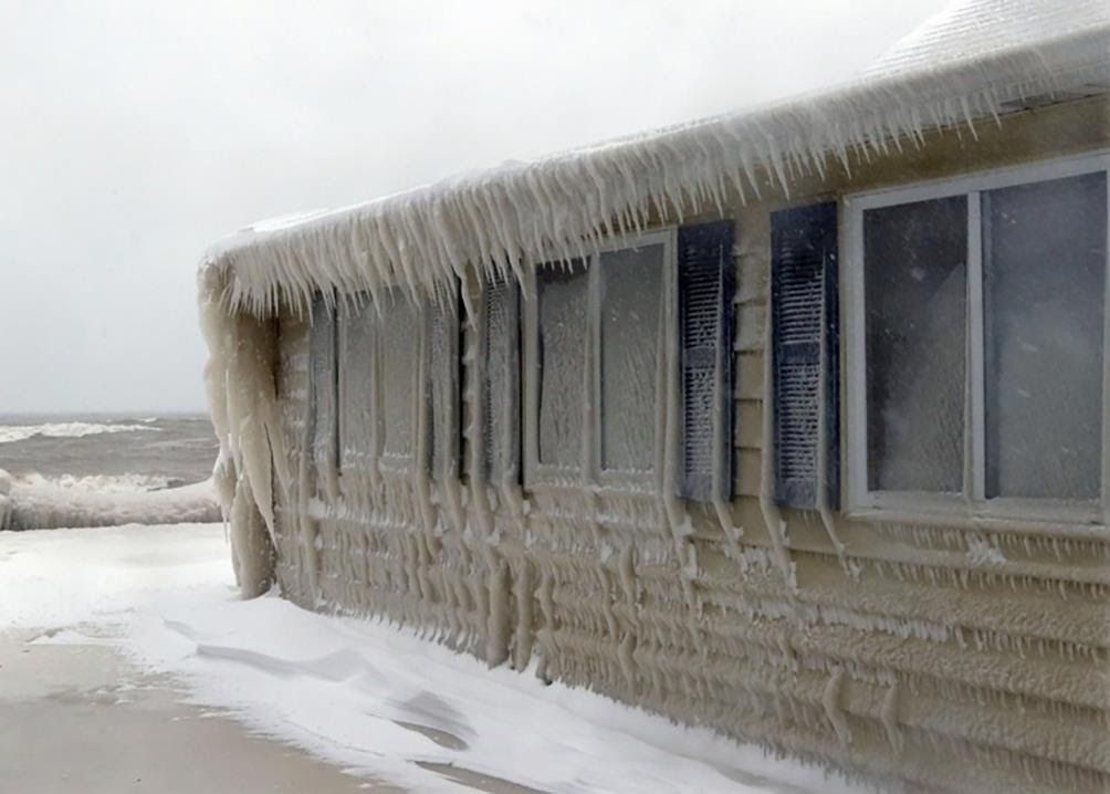
Winter Home Watch
WINTER HOME WATCH: The Ultimate Winter Home Protection Plan!
Secure your slice of paradise "Down the Shore" this off-season with our premier Winter Home Watch service!
Tired of the endless worry? Let our team provide the peace of mind you deserve. We are your dedicated eyes and ears, ensuring your investment is protected all winter long.
Unbeatable Value and Comprehensive Coverage
For an incredible value of just $1,199 per year, we offer weekly, rigorous inspections from October 1st through March 31st.
Our meticulous service goes above and beyond, including:
-Full Property Walkthroughs: Detailed interior and exterior checks
-Security Check: Ensuring all doors and windows are secure
-Systems Monitoring: Verification that HVAC, plumbing, and electric systems are in working order
-Pest Patrol: Early detection of any unwanted guests
-Other requested tasks as agreed upon, custom tailored to your home
Plus, we are available as your reliable, local point of contact for any emergencies. Don't just hope your home is okay - KNOW it is with MAX VALUE's expert care!
SPECIAL OFFER!!!
Sign up for a two-year Winter Home Watch agreement ($2,398 paid in advance) and earn a complimentary standard inspection of any home in NJ complete with a narrative report and high resolution photos ($449.00 value).
This reward is transferrable! Give your complimentary inspection as a gift!
Pricing
Payment is due IN FULL on date of scheduled appointment PRIOR to beginning the inspection. (All prices in $USD)
Single Family Homes and Townhouses:
$399.00 up to 1,000 square feet, up to two (2) bedrooms, and one (1) HVAC zone.
$449.00 1,001 to 2,000 square feet, up to three (3) bedrooms, and one (1) HVAC zone.
$499.00 2,001 to 3,000 square feet, up to four (4) bedrooms, and one (1) HVAC zone.
Add $50.00 for each additional <500 square feet of living space or additional bedrooms.
(3,001 sqft - 3,500 sqft = $549 / 3,501 sqft - 4,000 sqft = $599, etc.)
Add $50.00 for each additional HVAC zone.
Add $50.00 for a finished basement or attic as living space.
Add $50.00 for houses built between 1950 - 1976.
Add $100.00 for houses built before 1950.
Condominiums:
$399.00 for studio or efficiency units, single bedroom.
Add $25.00 for each additional bedroom.
Manufactured (mobile) Homes:
$399.00 single.
$449.00 double-wide.
Duplexes & Multi-Family Properties:
$475.00 for the first unit.
Add $125.00 for each additional unit.
New Construction:
Progress inspections $299.00 per visit.
Payment
Payment is due IN FULL on date of scheduled appointment PRIOR to beginning the inspection. (All prices in $USD)
We gladly accept cash, check, Zelle (preferred), PayPal, Venmo, and Stripe with major credit cards (3.2% service fee for credit cards)
$50 Deposit is required upon signing and returning the e-agreement. (All prices in $USD)
Deposit is payable by Zelle (preferred), PayPal, Venmo, or Stripe with major credit cards
(3.2% service fee for credit cards)